Eyes in the sky, space mirrors bouncing phone calls round Earth,
heavenly compasses helping us home—these are just three of the
things that satellites do for us. When you gaze through the
clouds on a brilliant blue day, you might catch sight of a plane or
two leaving vapor trails in its wake. But you're
unlikely to see all the thousands of meticulously engineered satellites, some
as small as your hand, some as huge as
trucks, spinning in orbits high above your head. "Out of sight, out
of mind" is probably one of the reasons we take satellites for
granted, even though they play a crucial part in everything from TV
broadcasting and transcontinental telephone calls to weather
forecasting and the Internet. What exactly is a satellite and how
does it work? Let's take a closer look!
Photo: NASA's Infrared Astronomical Satellite (IRAS) was effectively a remote-controlled telescope in space that surveyed the sky with infrared light.
Among other things, it discovered six new comets. Picture courtesy of NASA on the Commons.
A satellite doesn't necessarily have to be a tin can spinning
through space. The word "satellite" is more general than that: it
means a smaller, space-based object moving in a loop (an orbit)
around a larger object. The Moon is a natural satellite of Earth, for
example, because gravity locks it in orbit around our planet. The tin
cans we think of as satellites are actually artificial (human-built)
satellites that move in precisely calculated paths, circular or
elliptical (oval), at various distances from Earth, usually well
outside its atmosphere.
We put satellites in space to overcome the various limitations of
Earth's geography—it helps us step outside our Earth-bound lives.
If you want to make a phone call from the North Pole, you can fire a
signal into space and back down again, using a communications
satellite as a mirror to bounce the signal back to
Earth and its destination. If you want to survey crops or
ocean temperatures, you could do it from a plane, but a satellite can
capture more data more quickly because it's higher up and further
away. Similarly, if you want to drive somewhere you've never been
before, you could study maps or ask random strangers for directions,
or you could use signals from satellites to guide you instead.
Satellites, in short, help us live within Earth's limits precisely
because they themselves sit outside them.
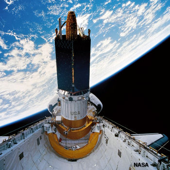
Photo: The Space Shuttle launches a communications satellite from its payload bay in 1995 by spinning it gyroscopically. You can see Earth just behind. Picture courtesy of NASA on the Commons.
Sponsored links
What do satellites do for us?
We tend to group satellites either according to the jobs they do
or the orbits they follow. These two things are, however, very
closely related, because the job a satellite does usually determines
both how far away from Earth it needs to be, how fast it has to move,
and the orbit it has to follow. The three main uses of satellites are:
Communications
Photography, imaging, and scientific surveying
Navigation
We'll now look at each of these in a bit more detail.
Communications
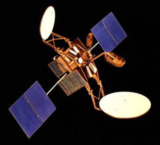
Photo: A typical communications satellite from the 1980s. The blue squares are
solar panels that provide power. The white circles are the sending and receiving antennas. Picture courtesy of NASA Glenn Research Center (NASA-GRC).
Communications satellites are essentially used to relay
radio waves from one place on Earth to another, catching signals that fire
up to them from a ground station (an Earth-based satellite dish),
amplifying them so they have enough strength to continue (and
modifying them in other ways), and then bouncing them back down
to a second ground station somewhere else. Those signals can carry
anything radio signals can carry on the ground, from telephone calls
and Internet data to radio and TV broadcasts. Communications
satellites essentially overcome the problem of sending radio waves,
which shoot in straight lines, around our curved
planet—intercontinental signals, in other words. They're also
useful for communicating to and from remote areas where ordinary
wired or wireless communications can't reach. Calling with a
traditional landline (wired phone), you need a very convoluted
network of wires and exchanges to make a complete physical circuit
all the way from the sender to the receiver; with a cellphone, you
can communicate anywhere you can get a signal, but you and the receiver
both still need to be within range of cellphone masts; however, with
a satellite phone, you can be on top of Mount Everest or deep in the
Amazon jungle. You're entirely free from any kind of
telecommunications "infrastructure," which gives you geographic
freedom and an instant ability to communicate (you don't have to wait
for someone to string up telephone lines or set up cellphone masts).
The best known modern communications satellite systems are probably INMARSAT and INTELSAT.
INMARSAT was originally a satellite system for ships, planes, and other travelers,
though it now has many other uses as well. INTELSAT is an international consortium that owns and operates several dozen
communications satellites that provide things like international broadcasting
and satellite broadband Internet.
How do communications satellites work?
What do they do?
Communications satellites are "space mirrors" that can help us bounce radio, TV, Internet data, and other kinds
of information from one side of Earth to the other.
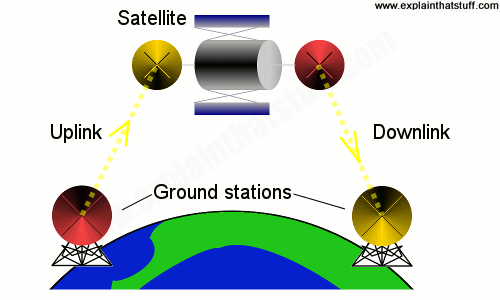
Uplinks and downlinks
If you want to send something like a TV broadcast from one side of Earth to the
other, there are three stages involved. First, there's the uplink, where
data is beamed up to the satellite from a ground station on Earth. Next, the
satellite processes the data using a number of onboard transponders
(radio receivers, amplifiers, and transmitters). These boost the incoming signals and
change their frequency, so incoming signals don't get confused with outgoing ones.
Different transponders in the same satellite are used to handle different TV stations carried on different frequencies.
Finally, there's the downlink, where data is sent back down to another ground station elsewhere on Earth. Although there's usually just a single uplink, there may be millions of downlinks, for example,
if many people are receiving the same satellite TV signal at once.
While a communications satellite might relay a signal between one sender and
receiver (fired up into space and back down again,
with one uplink and one downlink), satellite broadcasts typically involve one or more uplinks (for one or more
TV channels) and multiple downlinks (to ground stations or individual satellite TV subscribers).
Artwork: Communications satellites bounce signals from one side of Earth to the other, a bit like giant mirrors in space. A ground-based satellite transmitter dish (red) beams a signal to the satellite's receiving dish (yellow).
The satellite boosts the signal and sends it back down to Earth from its transmitter dish (red) to
a receiving dish somewhere else on Earth (yellow). Since the whole process happens using radio waves, which travel at the speed of light, a "satellite relay" of this kind usually takes no more than a few seconds, at most. The various transmitters and receivers on the satellite
and on Earth are examples of antennas.
Satellites are like any other vehicle inasmuch as they have two
main parts: the generic vehicle itself and the specific thing it
carries (the payload) to do its unique job. The "vehicle" part of
a satellite is called the bus, and it includes the outer case, the
solar panels and batteries that provide power, telemetry (a
remote-controlled system that sends monitoring data from the
satellite to Earth and operational commands back in the other
direction), rocket thrusters to keep it in position, and reflective
materials or other systems ("heat pipes") to protect it from
solar radiation and dissipate heat. The payload might include
transponders for a communications satellite, computers and atomic
clocks to generate time signals for a navigation satellite, cameras and
computers to images back to digital data for a photographic
satellite, and so on.
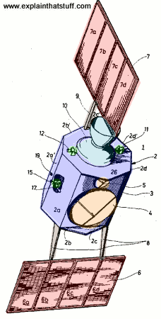
What's inside a satellite?
Artwork: Communications satellite. From US Patent: #3,559,919: Active communication satellite, courtesy of US Patent and Trademark Office.
These are amazingly complex and expensive machines with tons of electronic bits
and pieces jammed into them, but let's not get too bogged down in the details: the basic idea is very simple. In this outside view of a typical satellite, from a patent filed in 1968 by German engineer Hans Sass (US Patent: #3,559,919: Active communication satellite), you can see all the main bits and it's easy to figure out what they do.
I've left the original numbers on the diagram and I won't bother to label them all, since some are obvious and some are duplicates of others. The most interesting bits are the fold-out solar panels that power the satellite, the sending and receiving antennas that collect signals coming up from Earth and send them back down, and the motors and engines that keep the satellite in exactly the right position at all times:
4: Large parabolic dish antenna for sending/receiving signals. (Orange)
5: Small parabolic dish antenna for sending/receiving signals. (Orange)
6: Lower solar "battery" of four solar panels. (Red)
7: Upper solar "battery" of four more solar panels. (Red)
8: Supports fold out the lower solar panels once the satellite is in orbit. (Gray-brown)
9: Supports fold out the upper solar panels. (Gray-brown)
10: Main satellite rocket motor. (Light blue)
11, 12, 15, 17: Small control engines keep the satellite in its precision position, spin, and orbit. (Green)
Photography, imaging, and scientific surveying
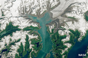
Photo: Satellite photography helps scientists understand our changing
planet. This image shows the Columbia Glacier in Alaska. By comparing it with
earlier images taken from the same viewpoint, we can measure the rate at
which climate change is taking place.
Picture by Lauren Dauphin using Landsat data from the US Geological Survey.
Image courtesy of NASA Earth Observatory.
Not so many years ago, newspapers used to run scare
stories about spy satellites high in space that could read newspapers
over your shoulder. These days, we all have access to satellite photos,
albeit not quite that detailed: they're built into search engines
like Google and Bing, and they feature routinely on the news (giving
us an instant visual impression of things like
disappearing rainforests
or tsunami destruction) and weather forecasts. Scientific satellites work in a
similar way to photographic ones but, instead of capturing simple
visual images, systematically gather other kinds of data over vast
areas of the globe.
There have been many interesting scientific
satellite missions over the last few decades. NASA's
TOPEX/Poseidon
and Jason satellites, for example, have routinely measured sea levels
since the early 1990s.
SeaWiFS (active until 2010) scanned the color
of the ocean to measure plankton and nutritional activity in the sea.
As its name suggests, a weather satellite called
TRMM (Tropical
Rainfall Measuring Mission) monitored rain near the equator from 1997
through 2015. As of 2016, NASA listed 25 ongoing satellite missions on
its website, including CALIPSO (which studies how clouds and aerosols interact);
Nimbus (a long-running scientific study of weather and climate using satellite data); and, the
longest-running and perhaps best known scientific satellites of
all-time, Landsat, a series of eight satellites that have been continuously mapping and monitoring changes in land use across Earth since 1972.
Photo: NASA's Jason-3 satellite, launched in January 2016, is part of a long-running project to monitor the height of Earth's ocean surface, producing
invaluable data for studying our planet's climate. Its main instrument is a very sophisticated
radar altimeter. Artist's impression courtesy of
NASA JPL.
Navigation
Finally, most of us with GPS-enabled cellphones and "sat-nav"
devices in our cars are familiar with the way satellites act like sky
compasses; you'll find GPS, Glonass, and similar systems discussed in
much more detail in our article about satellite navigation.
Satellite orbits
One of the most surprising things about satellites is the very
different paths they follow at very different heights above Earth.
Left to its own devices, a satellite fired into space might fall back
to Earth just like a stone tossed into the air. To stop that
happening, satellites have to keep moving all the time so, even
though the force of gravity is pulling on them, they never actually
crash back to Earth. Some turn at the same rotational rate as Earth
so they're effectively fixed in one position above our heads; others
go much faster. Although there are many different types of satellite
orbits, they come in three basic varieties, low, medium, and high—which
are short, medium, and long distances above Earth, respectively.
Low-Earth orbits
Scientific satellites tend to be quite close to Earth—often just
a few hundred kilometers up—and follow an almost circular path
called a low-Earth orbit (LEO). Since they have to be moving very
fast to overcome Earth's gravity, and they have a relatively small
orbit (because they're so close), they cover large areas of
the planet quite quickly and never stay over one part of Earth for
more than a few minutes. Some follow what's called a polar orbit,
passing over both the North and South poles in a "loop" taking
just over an hour and a half to complete.
Medium-earth orbits
The higher up a satellite is, the longer it spends over any one
part of Earth. It's just the same as jet planes flying over your
head: the slower they move through the sky, the higher up they are. A
medium-Earth orbit (MEO) is about 10 times higher up than a LEO. GPS
navstar satellites are in MEO orbits roughly 20,000 km (12,000 miles) above our
heads and take 12 hours to "loop" the planet. Their orbits are
semi-synchronous, which means that, while they're not always exactly
in the same place above our heads, they pass above the same points on
the equator at the same times each day.
High-Earth orbits
Many satellites have orbits at a carefully chosen distance of about 36,000 km (22,000 miles) from the surface.
This "magic" position ensures they take exactly one day to orbit Earth and always return to the same position
above it, at the same time of day. A high-Earth orbit like this is called geosynchronous (because it's synchronized with Earth's rotation) or geostationary (if the satellite stays over the same point on Earth all the time).
Communications satellites—our "space mirrors"—are usually
parked in geostationary orbits so their signals always reach the satellite dishes
pointing up at them. Weather satellites often use geostationary orbits because they need
to keep gathering cloud or rainfall images from the same broad part
of Earth from hour to hour and day to day (unlike LEO scientific
satellites, which gather data from many different places over a
relatively short period of time, geostationary weather satellites
gather their data from a smaller area over a longer period of time).
Small satellites
Think of a space satellite and you'll probably think of a giant shiny
can roughly the size of a truck. But not all satellites are so big.
In the last two decades, ingenious engineers have been experimenting
with tiny space-bound instruments that are smaller, simpler, cheaper,
bolder, more experimental, and less risky to launch.
In 1999, Bob Twiggs,
then a professor at Stanford University, kicked off this downshifting trend
when he proposed CubeSat, a satellite built from standardized modules in 10cm cubes, though even smaller satellites have been built since then. Today, it's quite common to read about picosats (generally weighing up to 1kg), nanosats (up to 10 kg), microsats (up to 100kg) and minisats (up to 500 kg).
In 2017, NASA launched the world's smallest picosat, weighing just 64g, packed into a 3.8cm cube,
and entirely manufactured using a 3D-printer.
Will satellites get even smaller in future? Not so fast! There are serious concerns that picosats
are too small to monitor properly and could present a major risk to other spacecraft
if they turn into unpredictable space debris.
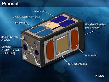
Artwork: The smallest satellites are about the same size as squared-off tennis balls. This
slightly bigger one has miniaturized antennas, a camera, solar cells, and rockets
packed into a box measuring 13 × 13 × 25cm (5 ×5 × 10in) and weighs 3.7kg (8lb).
It was the very last satellite launched from the Space Shuttle Atlantis when it flew its
final mission, STS-135, in July 2011. Photo courtesy of NASA.
Who invented satellites?
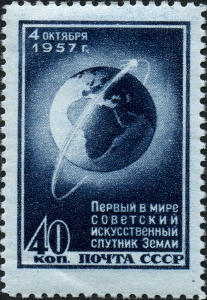
Artwork: Soviet engineers were the first to build a working satellite, Sputnik, and put it into space in 1957.
Stamps like this celebrated that stunning achievement. Artwork believed to be in the public domain, courtesy of
Wikimedia Commons.
The idea of using a satellite as a mirror in space—to bounce signals from one side
of Earth to the other—was "launched" in 1945 by science fiction author
Arthur C. Clarke (1917–2008), who wrote two hugely influential
articles setting out his plan in detail (one was unpublished, the other published as "Extra-Terrestrial Relays: Can Rocket Stations Give World-Wide Radio Coverage?" in Wireless World, October 1945). His proposal was to place three satellites
in a geosynchronous orbit 35,000km (23,000 miles) above Earth, spaced out evenly to cover about
a third of the planet each: one would cover Africa and Europe, a second would cover China and Asia, and a third would be dedicated to the Americas. Although Clarke didn't patent the geostationary communications satellite, he is generally credited with its invention, even though other space pioneers (notably German wartime pioneer Herman Oberth) had proposed similar ideas years before.
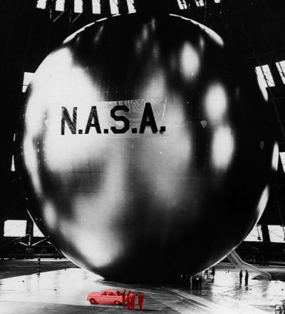
Photo: Echoes of history: Designed by NASA, the Echo communications satellite was a giant mylar balloon some 30m (100ft) in diameter designed to sit in space and bounce signals back like a mirror. You can see how big it is from the size of
the car and people at the bottom, which I've colored red to help you pick them out. Picture courtesy of NASA on The Commons.
It took another decade for Clarke's bold plan to move toward reality. First, satellites themselves had to be
proved viable; that happened with the launch of the Russian Sputnik 1 in October 1957. Three years later, when the Echo communications satellite was launched, engineers successfully demonstrated that radio telecommunications signals could be relayed into space and back, just as Clarke had predicted. Telstar, the first communications satellite, was launched in July 1962 and immediately revolutionized transatlantic telecommunications. During the mid-1960s, 11 nations came together to form INTELSAT (International Telecommunications Satellite Consortium), which launched the world's first
commercial communications satellite INTELSAT 1 ("Early Bird"), in geosychronous orbit, in April 1965.
This modest little space machine was a tiny electronic miracle: weighing just 35kg (76 lb), it could transmit 240 telephone
simultaneous calls or a single black-and-white TV channel.
Satellite imagery for everyone by Dexeter Jagula, IEEE Spectrum, 19 February 2022. How high-resolution satellite imagery is revolutionizing all sorts of industries—and how you can find images for yourself.
Potential Eyes in the Sky on Greenhouse Gases by William J. Broad. The New York Times, May 9, 2016. Scientists are calling for a new network of scientific satellites that can monitor carbon dioxide emissions more precisely.
9 Earth-Imaging Start-ups to Watch by Jean Kumagai. IEEE Spectrum, March 28, 2014. Looks at examples of new commercial satellites that are offering ever-better ways to study what's happening on Earth.
Microsatellites: What Big Eyes They Have by Anne Eisenberg. The New York Times, August 10, 2013. The latest generation of tiny satellites open up new business opportunities—and privacy concerns.
Tiny satellites can do big science by Prachi Patel, Space.com, 28 July 2010. A look at the work of small-satellite pioneers such as Bob Twiggs.
Patents
For those of you interested in deeper technical detail, here are a few representative examples of patented satellite designs from the last few decades:
Scientific satellite: US Patent: 2,835,548: Satellite
structure by Robert Baumann, May 20, 1958, assigned to the US Navy. Describes a scientific satellite that can carry sensors into Earth's atmosphere to make remote, automated measurements.
Navigation satellite: US Patent: 4,445,118: Navigation system and method by Ralph E. Taylor and James W. Sennott, April 24, 1984, assigned to NASA. Describes some of the technical details of the NAVSTAR Global Positioning System (GPS).
Communications satellite: US Patent: 3,710,255: Satellite communication system by Francis Gicca, January 9, 1973, assigned to Raytheon. Describes uplinks, downlinks, and satellite relays in quite a bit more detail than I've done above.
Satellite television: US Patent: 4,381,562: Broadcast type satellite communication systems by Anthony Acampora, April 26, 1983, assigned to Bell Labs. Describes a typical satellite TV broadcasting system using a small number of uplinks (from TV stations) and a much larger number of downlinks (to individual subscribers).
Small satellites: US Patent: 9,199,746: Attitude control system for small satellites by Vivek Nagabhushan et al, assigned to University of Florida Research Foundation Inc, December 1, 2015. An overview of some of the design issues concerning small satellites (picosats and so on).
Satellite images of Earth
USGS Landsat: Explore satellite photos of Earth with the US Geological Survey's Landsat satellite.
DigitalGlobe: Another good source of satellite photos of Earth.
Google Earth: Google's ambitious plan to map the planet in 3D.
Please do NOT copy our articles onto blogs and other websites
Articles from this website are registered at the US Copyright Office. Copying or otherwise using registered works without permission, removing this or other copyright notices, and/or infringing related rights could make you liable to severe civil or criminal penalties.